
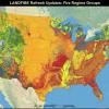
The Northern Rockies and Southern Rockies Fire Science Networks and the Joint Fire Science Program have teamed up with LANDFIRE to offer a three-part webinar series. The webinar series is designed to introduce LANDFIRE data and tools, examine an on-the-ground application project in the Rockies region, and look at ways to customize LANDFIRE data for use on specific landscapes and projects. ​

The series is designed to help land managers and others understand and use data resources to assist them when making decisions regarding large landscape projects. ​Because the suite of LANDFIRE tools are based in vegetation history and current conditions, they can be applied in both fire and non-fire related activities and are particularly suited for running scenarios and considering management plans.

Read about LANDFIRE.

Screenshot from LANDFIRE
Feb 19 2014, 10am
This is the first webinar in a series of three, developed by LANDFIRE, the Northern Rockies and Southern Rockies Fire Science Networks, and the Joint Fire Science Program.  Randy Swaty, ecologist with The Nature Conservancy’s LANDFIRE Project, will…

People in a classroom, looking at laptops
Mar 20 2014, 10am
This is the second webinar in a series of three, developed by LANDFIRE, the Northern Rockies and Southern Rockies Fire Science Networks, and the Joint Fire Science Program. Joe Scott has more than 15 years experience in wildland fire science…

LANDFIRE maps
Apr 23 2014, 10am
This is the third webinar in a series of three, developed by LANDFIRE, the Northern Rockies and Southern Rockies Fire Science Networks, and the Joint Fire Science Program. In this webinar, Don Helmbrecht (Wildland Fire Analyst with the USDA Forest…